When you read as many articles during the course of a week as I do, every now and then one creeps back to the forefront your mind. This one was an article about the increase in tickets being beat by drivers using GPS devices. What is important to remember about this is the economic times we currently live in. It is no secret that law enforcement agencies across the nation are writing more tickets for lesser infractions and issuing fewer warnings to drive dollars into the local government. More tickets, more fights, and in this case, more victories at the hands of GPS technology armed drivers. So I decided to see how easy it would be to beat a ticket using my cell phone. The results my surprise you!
The phone
The phone
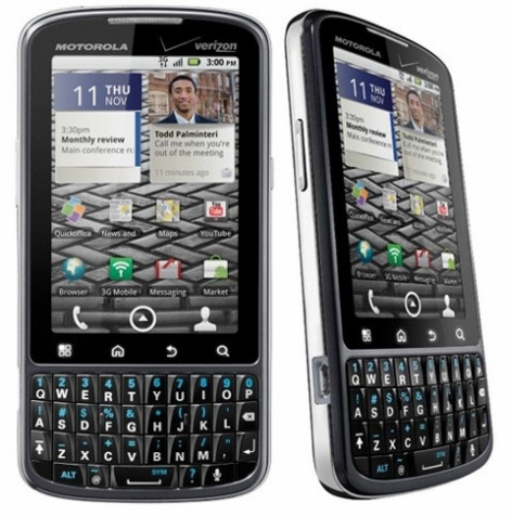
Verizon Droid Pro
My Droid Pro was perfect for this. Android version 2.2.1 / system version 2.26 powered by a 1GHz Snapdragon processor. The phone has a 2GB internal memory and (disappointingly) came with a 2GB SD card that was swapped with the 16GB SD card from my previous Droid (though it is expandable to 32GB). What made the phone ideal for this is its ability to run multiple apps simultaneously without slowing, freezing and shutting down.
The idea was to use free GPS apps to track and record every inch of a road trip from Sierra Vista, AZ to Marana, AZ and be able to prove beyond a reasonable doubt my travel speed at any giving point in the 200-mile round trip drive.
The apps
The idea was to use free GPS apps to track and record every inch of a road trip from Sierra Vista, AZ to Marana, AZ and be able to prove beyond a reasonable doubt my travel speed at any giving point in the 200-mile round trip drive.
The apps
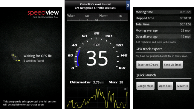
Speedview free app
Google Maps, Navigation, Latitude; which all come installed on the Droid, along with Speedview and Maverick which were installed for the test. Both Speedview and Maverick were tracking between 8 and 13 satellites and proved more accurate than the car’s speedometer. To compare Speedview v. Maverick v. car I timed 1, 5, 10, 20 and 50 mile increments over the time traveled. Speedview and Maverick were both +/- .0001 mph and the car was +/- 3.78 mph when put against good old-fashioned math.
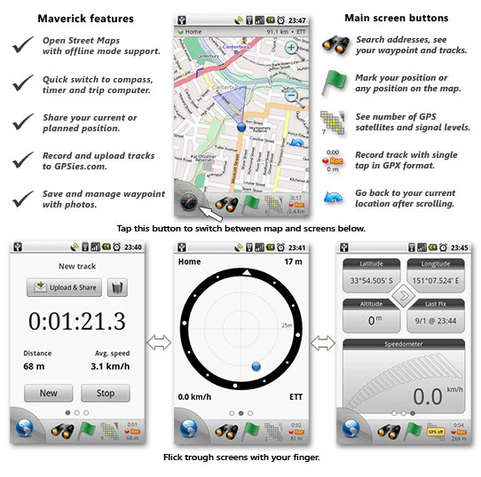
Maverick free app
Speedview interfaces with both Google Maps and Maverick and exports the GPS files to the SD card making it very user friendly. Maverick however only records when the SD card is available. This is somewhat of a problem because the GPS must remain on in order to track data accurately; enabled GPS on a cell phone is a battery hog forcing the operator to have the phone charging while GPS is in use. If using a USB port in the car, be sure to set the phone to “charge only” as the USB connection will seek to access the SD card preventing Maverick from sending data to the external memory device.
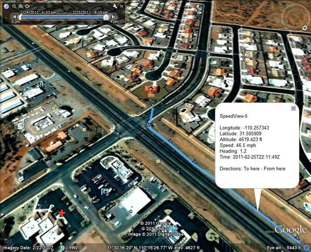
The GPS track files from both Speedview and Maverick can be imported to Google Earth 6 where it will map the data and provide you with the proof you will need with unbelievable accuracy!
The GPS track files from both Speedview and Maverick can be imported to Google Earth 6 where it will map the data and provide you with the proof you will need with unbelievable accuracy!
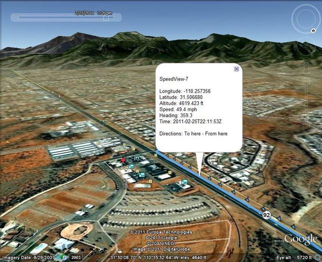
This is the start of trip leaving my house in Sierra Vista. Here’s the cool part! Each light blue arrow is a data point containing longitude, latitude, speed (measured to the tenth of a mile per hour), heading, date, and time (measured to the tenth of a second). As you can see, with up to 13 satellites tracking at any given point (though there were only 9 when I left) provides you with very dense data feedback.
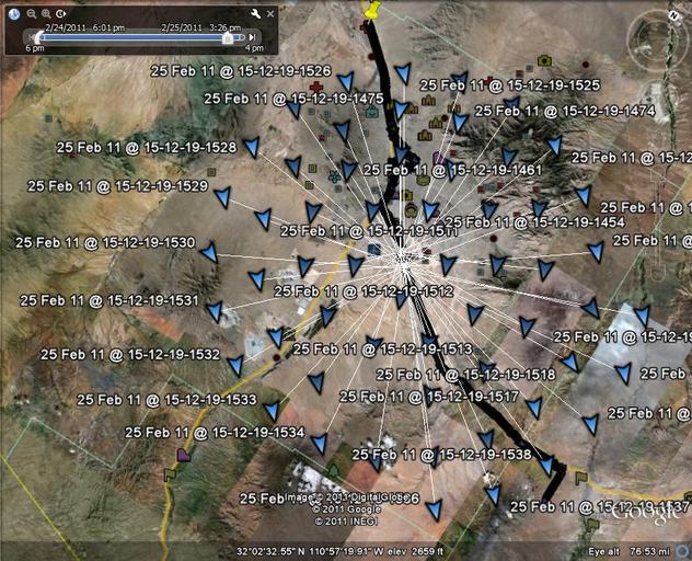
So much data feedback that it can be overwhelming. As you zoom out on Google Earth and click on your course, the data points literally explode off the selected area. Each arrow contains the same data as the screen above.
In the event that you were to get a ticket, it is important that you “flag” the location of the stop! It is easiest to do this with Maverick by simply tapping the green flag while in the map display screen. Flagging this location will make it easier to extract the data from Google Earth as it will serve as a waypoint. The issued citation will provide further data to aide in locating the specific location on your GPS print out; statements like “mile marker 250,” or “exit 398” are routinely listed. By doing this at the time of the ticket, it will enable you to select the exact location of the stop and assess your traveling speeds prior to being pulled over.
The point of truth
By now you may have realized something; by seeking to disprove, you also set yourself on a course to prove. Going back to the beginning where we leaving my house in Canyon De Flores, if we were cited for running the light at Canyon De Flores and Highway 92 I can easily pull the data from not only being at a stop, but pulling the data from the subsequent points I can show how long I was at a stop. At the same time it is important to remember that opposite is true. If the speed limit were (hypothetically) 35 mph on Highway 92, I can only prove the only time traveling under 35 mph was from the stop as we accelerated to 55 mph and the ticket is thus legit. What this process proves is truth as provided by technology equal to that of law enforcement and more accurate than “pacing strategies” many law enforcement agencies still use. If you are speeding, you are speeding and GPS will not prove innocence where it does not exist. However, it can correct an error on the part of law enforcement, spare you the trouble of a fraudulent citation, and provide beyond a reasonable doubt the exact details of your course of travel. When this differs from the claims of law enforcement, you have a tool that is winning in traffic courts across the land. Just understand that it will not claim you were doing 64 in a 65 when you were actually traveling 72!
Truth be told, the conservative nature of people dictates that if we are speeding, we do not mind the ticket; we do however, insist the citation be accurate! Those whom believe in personal accountability will accept a ticket for doing 72 in 65 if they believe they were going roughly 72. It is when we are told they were doing 76 and cited for it when we last looked at the speedometer being just over 70. Here is where such clarity will become helpful. In such an error, a new citation cannot be issued to correct the speed as an admission of guilt through GPS technology; the original citation must be thrown out and you get off scot-free by being 100% honest due to law enforcement inaccuracies.
Truth be told, the conservative nature of people dictates that if we are speeding, we do not mind the ticket; we do however, insist the citation be accurate! Those whom believe in personal accountability will accept a ticket for doing 72 in 65 if they believe they were going roughly 72. It is when we are told they were doing 76 and cited for it when we last looked at the speedometer being just over 70. Here is where such clarity will become helpful. In such an error, a new citation cannot be issued to correct the speed as an admission of guilt through GPS technology; the original citation must be thrown out and you get off scot-free by being 100% honest due to law enforcement inaccuracies.


 RSS Feed